
Jim Lewis astrocartography is the Astro*Carto*Graphy map method developed and popularized by astrologer Jim Lewis, showing where planets were angular at a birth moment. Learn what he contributed, then use AstroCarto to find your own lines and understand one familiar city. You do not need a book to begin. This is an independent guide and tool.
THE PERSON · THE METHOD · YOUR OWN MAP
Jim Lewis Astrocartography
Explore the method on your own map
Enter your birth details, generate your map, then check one city. The basic map is free; location previews are limited and advanced tools have separate access requirements.
Explore the history, method, and city exercise
What Jim Lewis contributed to astrocartography
Jim Lewis astrocartography belongs to a longer history of connecting astrology with place. Lewis, an American astrologer who lived from 1941 to 1995, did not invent every form of location astrology. His contribution was to make a particular angular-map method accessible through maps, written interpretations, software, lectures, and training. Robert Currey’s published obituary documents that combination and records Lewis’s 1992 Regulus award for research and innovation within astrology.
That combination explains why his name still appears when people look for a personal map. A world map lets someone see the same birth moment from many locations. A map key identifies the lines. Interpretation then gives the reader a way to connect an abstract label with questions about work, relationships, or home. Those are distinct steps, even when a modern interface presents them together.
There is also a concrete historical artifact behind Jim Lewis astrocartography. The United States patent record for Astrological device and method, US4304554A, names James L. Slayden, Lewis’s birth name, as inventor. Filed in 1980 and published in 1981, it documents the development of a physical astrological map device. A patent is evidence of an invention record, not a demonstration that astrological interpretations predict life events.
The useful distinction today is between the underlying method, the original map products, and later software. An independent tool can calculate angular lines without reproducing Lewis’s handbook or being his original service. A contemporary explanation, score, or AI answer needs its own attribution. Understanding that distinction lets you explore his legacy without mistaking every feature on a modern screen for something he designed.
Four angles, four different questions
The starting point for Jim Lewis astrocartography is a fixed moment, usually a birth. At that instant, a planet has different relationships to the local horizon and meridian around the globe. A line connects places sharing one of the relevant angular relationships. The planet provides the symbolic theme; the angle changes where the interpretation directs your attention.
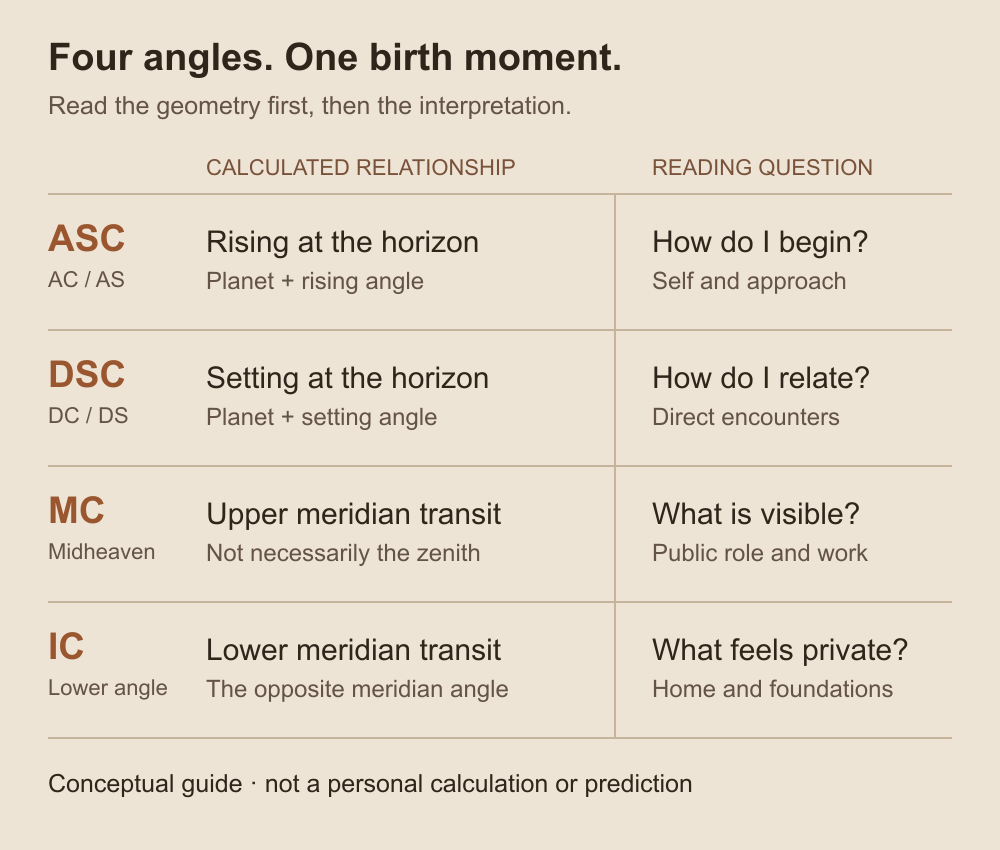
A conceptual label guide, not a personal calculation or a reproduction of an original map. Geometry identifies the relationship; astrology supplies the symbolic interpretation.
| Angle | What the line identifies | A question to explore |
|---|---|---|
| ASC / AC / AS | Places where the planet was rising | How might I express myself or approach beginnings? |
| DSC / DC / DS | Places where it was setting | What might matter in direct relationships and partnerships? |
| MC / Midheaven | Places where it was at upper meridian transit | How might I approach visibility, responsibility, or public work? |
| IC | Places where it was at lower meridian transit | What might matter in home life and private foundations? |
This is why “I have a Venus line” is an incomplete observation. Venus DSC and Venus MC carry the same planetary theme into different areas of life. Before selecting an appealing interpretation, read the full label. A rising sign in a natal chart is also different from a particular planet’s rising line on a world map.
Two details prevent common mistakes. Upper meridian transit does not mean a planet was directly overhead at every point on an MC line. And a natal map remains tied to its original moment: it does not redraw itself each morning. Changing the birth time changes the geometry; examining current transits is a different task. Accurate input matters more than adding increasingly elaborate interpretations to uncertain data.
Start with a city you already know
You can explore Jim Lewis astrocartography before reading any historical text. Choose a familiar city and begin with a method question: “Which parts of this result show the angular map, and which parts explain or extend it?” Keeping one location in view makes that distinction easier to follow than comparing several destinations at once.
Enter your birth date, recorded time, and birthplace in the form above. If you do not know the time, use the unknown-time option and keep that limitation with your result. An invented exact time can produce a precise-looking map without a sound basis for its angular positions.
After generation, use Check City for your chosen place. Read the accessible line cards for the planet, angle, approximate distance, and strength. Record the city and coordinates with those fields. If you later select a different point on the map, check its location before treating the new answer as a description of the same place.
When you select a place, look for Start with the answer. This contemporary preview connects the visible evidence with a life area, a planetary theme, and an emphasis. Expand See why we reached this answer to inspect the supporting lines and distances. You now have both an explanation and something specific to compare it with.
For your first Jim Lewis astrocartography exercise, keep two notes: what the tool identifies and what it says that configuration means. A line label belongs in the first note; a sentence about confidence, relationships, or belonging belongs in the second. The exercise below shows how to connect them without losing the distinction.
Distance describes a geographic relationship to a mapped line, not a driving route or a probability of success. The line distance guide explains how to keep proximity in context. Preserve any birth-time uncertainty and other visible signals when you interpret the number.
One city, three layers of a modern result
Imagine learning about Jim Lewis astrocartography, creating your map, and opening a familiar city. A line card gives a planetary label; the place answer describes a life theme; another available panel may show additional signals. It is easy to read the whole screen as one explanation inherited from Lewis. A more useful question is: “What kind of statement am I looking at, and what supports it?”
This is a conditional walkthrough using your own accessible result. No city has been calculated for this example, and it does not assume that every panel or signal is available. Keep the labels and distances actually shown rather than substituting the illustrative label below.
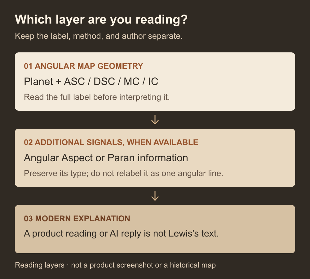
A guide to reading a result, not a product screenshot. Additional signals remain separate types; the diagram does not date their invention or attribute them all to one author.
First, identify the angular relationship
Suppose an accessible line card shows Sun MC. Sun identifies the body and MC identifies upper meridian transit, the relationship introduced in the four-angle guide. Your actual distance describes how the selected place relates to that line. You can now say which angular configuration you are examining, rather than referring to the city as vaguely “solar.”
Notice that the card also provides a strength label and a theme explanation. Those are AstroCarto’s presentation of the result. Recognizing the underlying angular geometry does not make the entire card an extract from the original handbook. Keep the exact label and distance, then read the explanatory wording as a separate part of the experience.
If your result shows another planet or angle, apply this distinction to that combination. The point is to recognize the method in your own result, not to find a Sun MC line somewhere merely to complete the example.
Then, inspect any additional signal on its own terms
If the available result identifies an Angular Aspect, retain its full label, including the aspect information shown. Do not shorten it to a classic angular line because it mentions the same planet or angle. Currey’s historical account distinguishes Lewis’s angular emphasis from aspect-line approaches; matching a familiar name is insufficient to establish that two results use the same method.
If Paran information is available, preserve its type and participating planets. A paired signal should not be rewritten as one planet’s MC or rising line. The Paran guide explains that separate reading task. “Additional” here describes its place alongside the angular-line exercise, not a claim that the technique was invented recently or was unknown to Lewis.
An unavailable or locked panel gives you nothing further to classify yet. Likewise, a neutral place answer or no relevant visible line does not justify inventing one. Check the selected location, enabled lines, and accessible evidence. A partial record is more useful than a complete-looking record assembled from assumptions.
Finally, trace the modern explanation to its evidence
Return to Start with the answer and expand its supporting evidence. Which visible line underlies the stated life area and planetary theme? If the answer concerns several influences, keep that context instead of assuming the first line you noticed explains everything. If you cannot establish the connection, leave a question for follow-up.
For example, a public-life theme can be consistent with an MC label. That connection helps you understand the product’s interpretation; it does not establish that Lewis wrote the sentence, that the wording came from a particular edition, or that the suggested outcome will happen. A modern answer and a historical quotation require different kinds of support.
Keep a simple record as you finish this Jim Lewis astrocartography exercise:
| Part of your result | What to keep in your note | What you can do next |
|---|---|---|
| Angular line | Actual planet, angle, distance, and displayed strength | Relate the full label to the four-angle explanation |
| Additional signal, if available | Its stated type and complete participating labels | Read the explanation for that type before comparing it with the angular line |
| Place answer or later AI explanation | The interpretation and the evidence it refers to | Ask about an unclear connection; check historical wording separately |
The useful outcome is an account of your own result that preserves these distinctions. You can identify the angular map, recognize when another technique enters the reading, and explain which conclusions belong to the current tool. That makes both further reading and a follow-up question more precise.
Optional reading: a map handbook or the psychology book?
Once you have inspected a city, a book can deepen the questions you ask. It is not an entry requirement. Researching Jim Lewis astrocartography often brings up two different kinds of material: the explanatory handbook associated with the original map kit and The Psychology of Astro*Carto*Graphy. Treat them as different resources rather than interchangeable names for the same text.
The psychology book appeared in 1997 under Jim Lewis and Kenneth Irving’s names, with a foreword by Erin Sullivan. Robert Currey’s review emphasizes its attention to the natal chart and interacting influences. That makes the distinction useful: a map companion helps a reader orient themselves to a supplied map, while a fuller discussion can explore why isolated line descriptions may miss broader context. This guide draws on the published review and bibliographic details, not a claim to reproduce or review the entire book.
| What you want to understand | A useful reading route | Bring this question from your map |
|---|---|---|
| The labels on an original map | Its accompanying key and handbook | Does the explanation match the exact planet and angle? |
| Why one line may not tell the whole story | A fuller interpretive discussion | What other chart context is being considered? |
| Lewis’s contribution to the field | A biography or historical account | Which method or product is the author describing? |
| Your own selected city | Your calculated result alongside relevant reading | Is the configuration discussed actually present? |
Record the title, author, and edition before applying a passage. Notice whether it concerns one angular line, several influences, or the wider chart. A passage can be meaningful without describing your selected place. That small source check turns further Jim Lewis astrocartography reading into a comparison you can follow, rather than a search for whichever sentence feels most reassuring.
Ask about the method behind your city result
After the walkthrough, you may recognize a label without yet understanding the link between that label and the place answer. For Jim Lewis astrocartography study, that is a focused reason to continue: you want to understand the calculation and explanation you actually have, rather than obtain a generic account of your future.
Where Ask AI is available from Check City, AstroCarto passes the current city, coordinates, and listed planet, angle, distance, and strength into the conversation. Add your learning question yourself. The tool does not automatically know why you are studying the method, and the city-check context is not a copy of every panel you may have opened elsewhere.
A useful prompt for this exercise is: “For the angular lines attached to this city, explain what each full label identifies and how the displayed distance relates to the place. Then separate those calculated relationships from your modern symbolic interpretation. Say what the supplied evidence cannot establish.” This is a suggested question, not a recorded exchange or a sample AI answer.
If you also want to discuss an additional signal, include the full label from the accessible result and say where it appeared. Do not assume an aspect or Paran seen in another panel was automatically attached to this question. The follow-up should retain that signal’s type rather than folding it into a familiar angular-line explanation.
Read the answer against your notes. Has it retained the actual labels? Does it distinguish the place’s relationship to a line from what that line is interpreted to mean? If it claims to reproduce Lewis’s words, a confident attribution alone is insufficient: consult the identified publication and passage. AI can help explain the current evidence; it does not certify an author’s text or an original service’s authorization.
You have made progress when you can identify the part you understand and name what remains unresolved. You might next read the matching angle section, investigate a separately labeled signal, or consult a relevant source. The basic map is free, location previews are limited, and advanced tools have separate access requirements. Begin with the evidence available to you; a missing extra panel does not prevent you from learning the angular method.
Questions about Jim Lewis astrocartography
Did Lewis invent all location astrology?
No. He developed and popularized a particular map-based approach within an older field. Relocation charts, directional techniques, timing methods, and later digital tools should not all be attributed to one person. Identify the method before attaching a historical name to it.
Is this the original or an officially authorized service?
No. This Jim Lewis astrocartography guide is published by AstroCarto, an independent product. Its map, previews, and AI are AstroCarto features. This page does not supply Lewis’s original handbook, claim certification, or imply endorsement by his estate.
Do I need a book before creating my map?
No. Start with your birth details and a familiar city. Read the complete label, inspect the available evidence, and identify the life question it helps you explore. Historical reading becomes an optional next step once you have a specific configuration or method question to investigate.
What if my birth time is uncertain?
Keep that uncertainty explicit. Angular positions depend on the moment used, so a guessed time can change the lines you are interpreting. Use the unknown-time option when appropriate, and avoid treating a detailed-looking output as evidence that the input was accurate.
Does the map prove where I should live?
No. Calculating a planetary relationship and validating a claim about your future are different tasks. Housing, work, relationships, and personal preferences require their own evidence. The evidence and limitations guide explores the distinction between map geometry and astrological claims.
Why might two maps look different?
Compare birth details, time conversion, included bodies, signal types, projection, and labels before drawing an interpretive conclusion. A color change may be cosmetic; a different time or added aspect layer may change what is being shown. Compare equivalent configurations, not screenshots as a whole.
See how the method appears on your own map
Check one familiar city. Identify its angular lines, inspect the evidence behind the place answer, and separate the map calculation from its modern interpretation.
Create my map